The <imagemap> element supports the basic functionality of the
HTML "client-side" image map markup. <imagemap> allows you to
designate a linkable area or region over an image, allowing a link in that region to display
another topic.
An HTML client-side image map binds an image to the navigation structure (the "map") by means of
an ID association from the map to the image. In contrast, the DITA version of
<imagemap> markup simply includes the target image as the first required
element in the markup, followed by a sequence of <area> elements that
represent the links associated with the contained image.
An <imagemap> structure can be output either to a standard HTML image map
or to alternative forms of navigation (such as table-based image maps). When output as PDF, the
minimal form would be to represent at least the image; advanced PDF output processors should be
able to provide equivalent region-oriented hyperlinks.
The <xref> content within <area> contains the
intended alternative text or hover text for that image map area.
Content models
See appendix for information about this element in OASIS document type shells.
Inheritance
+ topic/fig ut-d/imagemap
Example
<imagemap> looks like this (note that the rendering will depend
on how this markup is supported for particular output
formats):<imagemap> <image href="imagemapworld.jpg"> <alt>Map of the world showing 5 areas</alt> </image> <area><shape>rect</shape><coords>2,0,53,59</coords> <xref href="d1-s1.dita">Section 1 alternative text</xref> </area> <area><shape>rect</shape><coords>54,1,117,60</coords> <xref href="d1-s2.dita"><!-- Pull title from d1-s2.dita --></xref> </area> <area><shape>rect</shape><coords>54,62,114,116</coords> <xref href="#inline" type="topic">Alternative text for this rectangle</xref> </area> <area><shape>circle</shape><coords>120,154,29</coords> <xref format="html" href="test.html">Link to a test html file</xref> </area> <area><shape>poly</shape> <coords>246,39,200,35,173,52,177,86,215,90,245,84,254,65</coords> <xref format="pdf" href="test.pdf">Link to a test PDF file</xref> </area> </imagemap>
The areas defined correspond to this graphic image with the areas visible: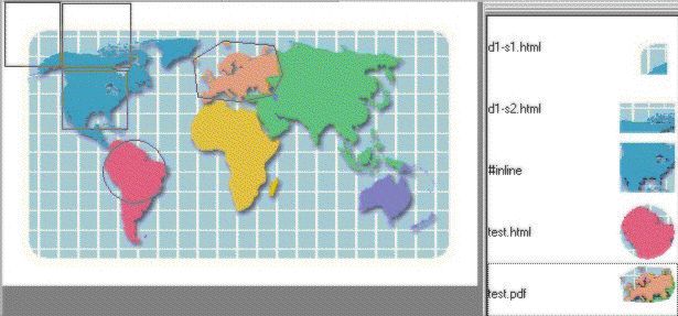
The values for use in the <shape> and <coords>
elements must follow the guidelines defined for image maps in HTML 4.1, Client-side
image maps: the MAP and AREA elements
Attributes
The following attributes are available on this element: Universal attribute group, Display attribute group, outputclass, and spectitle.